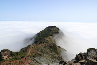
Vereada do pico ruivo
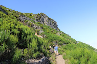


O Pico Ruivo é o ponto mais alto da Madeira com 1862 m
Este e um percurso popular
A rota e moderada e inicia se no parque de estacionamento de Achada do Teixeira ja a 1590 m, acessível por estrada a partir de Santana.
A partir do parque de estacionamento para a o cume são 2,8 km
O percurso e largo e pavimentado com pedra.
Existem vários abrigos e um refugio com bar
The Pico Ruivo is the highest point of Madeira with 1862 m
This is a popular route
The route and moderate and starts in the parking lot of Achada do Teixeira to 1590 m, accessible by road from Santana.
From the parking lot to the summit are 2.8 km
The route, wide and paved with stone.
There are several shelter and refuge with bar


IMPORTANTE
Recomendações a considerar em caminhadas
Prestar atenção a dificuldade do percurso indicado. Alguns dos percursos apresentados como pequena rota (PR) como os de grande rota (GR) podem ter alguma dificuldade, ou grandes desníveis, terreno irregulares e rochoso, ou porque ainda inclui etapas perigosas ou difíceis.
Nunca faça percursos sozinho, mas sim de preferência em grupo. Antes de iniciar o percurso avise no seu local de alojamento, em abrigos ou familiares, o itinerário e a hora prevista da viagem. pode deixar, ainda, uma nota sobre o assunto no painel do seu carro, visível do exterior.
Leve roupas adequadas as condições atmosféricas e uma protecção da chuva, pode ser surpreendido a qualquer momento.
Use calcado para caminhadas ou montanhismo (trekking/mountaineering)
No inverno, usando roupas adequadas para ambientes frios.
Leve agua necessária para as condições atmosféricas ja que no verão e no outono poderá falhar. Além disso, a água podera não ser tratada mesmo nas aldeias.
É conveniente levar pastilhas desinfectantes para o caso de falhar a agua que levou.
O nevoeiro e pior inimigo nas montanhas, onde o nevoeiro aparecer subitamente.
Mesmo que conheça a área é melhor procurar um abrigo/refúgio antes que perca a visibilidade.
Em caso de se perder, é melhor procurar um abrigo/refugio mais próximo e esperar por salvamento.
A cobertura telefónica móvel na montanha poderá ser limitada ou mesmo inexistente.
Ter em especial atenção no inverno:
Atenção as marcas de tinta,no inverno a neve pode esconder as marcas
A neve pode bloquear a passagem, especialmente em zonas altas
Com nevoeiro não faça o percurso
Leve agua necessária para as condições atmosféricas
Use calcado para caminhadas ou montanhismo (trekking/mountaineering)
IMPORTANT
Recommendations to consider in hiking
Watch the difficulty of the indicated route. Some of the routes presented as short route (PR) as a major route of the (GR) may have some difficulty, or
large gaps, uneven and rocky terrain, or because even includes dangerous or difficult steps.
Never paths alone, but preferably in groups. Before starting the route advise at their place of accommodation, in shelters or family, the itinerary and time
planned the trip. You can leave also a note about it in your car's dashboard, visible from the outside.
Take appropriate clothing atmospheric conditions and a rain protection, may be surprised at any time.
Use trampled for hiking or mountain climbing (trekking / mountaineering)
In winter, wearing appropriate clothing for cold environments.
Take the water needed to atmospheric conditions already in the summer and fall may fail. In addition, the water can not be treated in the same villages.
It should take disinfectant tablets for the case of loss of water it took.
The fog and worst enemy in the mountains where the fog suddenly appear.
Even if you know the area is better to seek a shelter / refuge before you lose visibility.
In case you get lost, it is best to seek a shelter / nearest refuge and wait for rescue.
Mobile phone coverage on the mountain may be limited or even nonexistent.
Pay particular attention in winter:
Attention ink marks in the winter snow can hide marks
Snow can block the passage, especially in high areas
With fog did not make the route
Take the water needed to weather conditions
Use trampled for hiking or mountain climbing (trekking / mountaineering)